



When we discuss the digitalization of disaster risk management, we tend to focus on how quickly the damage can be assessed. However, in my view, that is not the true merit of using urban “digital twins,” which are complete digital replicas of real-world cities.
In digital-twin cities, real-world city structures, including the workings of infrastructure such as roads, waterworks, sewage systems and buildings and the movement of people, are all reproduced in a computer environment. Unlike maps, digital twin spaces can be dynamically manipulated by instituting different parameters. What would happen if this bridge collapsed, or if this road were narrowed? Digital twin simulation allows us to test such scenarios without making physical changes to real-world cities.
According to a study that examined how digital-twin cities are used, the usage disproportionately leans toward the maintenance and management of infrastructure. Since the interim review of the Sendai Disaster Risk Management Framework, it is hoped that digital twin technology will serve as a platform for harmonizing and integrating the various disaster risk management approaches that have until this point advanced in a fragmented manner.
However, for a country facing a declining population and shrinking public finances, there is a more fundamental question that should be answered before the question of how to maintain and manage infrastructure: Which infrastructure assets should be preserved in the first place?
In addition to protecting and maintaining infrastructure, digital twins can serve as a tool in deciding what should be scaled back or retired.
Efficient Cities Tend to Have Vulnerabilities
According to a study that compared road networks in 40 U.S. cities. It calculated how much congestion-related delay would increase if 5% of roads were made unusable. The results showed an increase of 9.5% in Los Angeles and 56.0% in San Francisco. The same 5% disruption caused as much as a sixfold difference across different cities.
Moreover, the same study showed that the more efficient a road network is in normal times, the more vulnerable it becomes in the event of a disaster. The absence of redundancy means the city lacks alternative routes which would provide shock-absorbing capacity.
So what sorts of roads are critical? According to a study that analyzed transportation networks in Tanzania from a supply chain perspective, roads that are critical to a stable food supply are not necessarily the same as those critical to imports and exports. The list of critical infrastructure varies from country to country depending on the items that are important for each country.
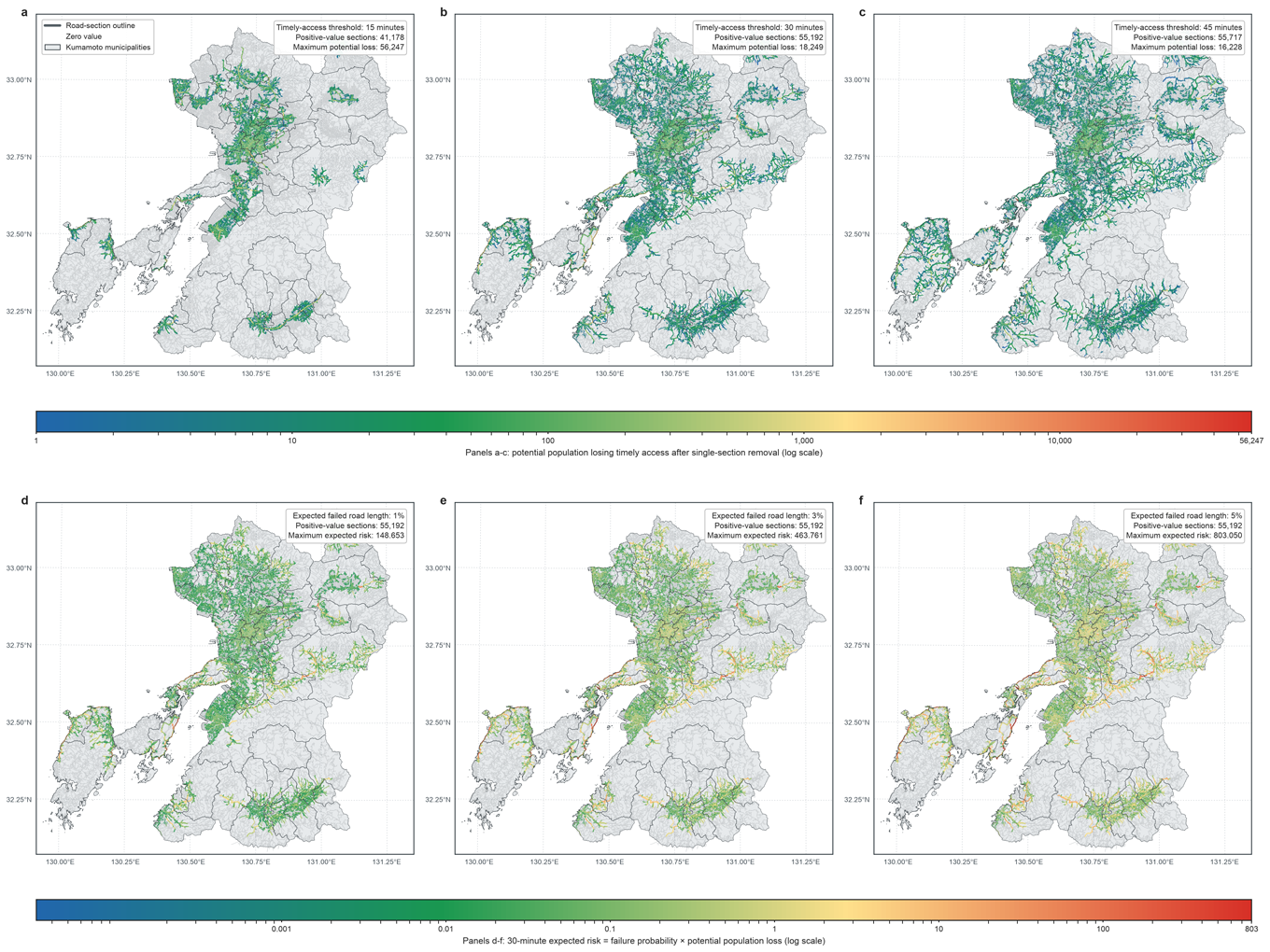
A similar finding was obtained from the estimation that we conducted with respect to the impact of the Kumamoto Earthquake (Kyushu University press release in Japanese). Of the approximately 340,000 road segments in Kumamoto Prefecture, 83.9% of the road segments could each individually become impassable and have no effect on emergency service access in terms of whether a person who needs the service can reach an emergency medical care facility within 30 minutes. On the other hand, if a single, specific road segment were to become impassable, it is estimated that 18,249 people would lose the 30-minute access to emergency services. In essence, the parts of the infrastructure that truly needs protection are much fewer and more geographically concentrated than you might assume.
[Click to enlarge]
Levee Construction Encourages More Settlement
The question of whether certain infrastructure assets are really necessary is more difficult to answer than might be expected. Simply calculating the number of people currently depending on the infrastructure is not sufficient.
According to a study that analyzed the correlation between levee construction and changes in land utilization across the United States, the pace of urban expansion accelerated 62% beyond previous levels in floodplain areas following the construction of levees, compared with the county-wide average acceleration rate of 29%. Infrastructure designed to reduce risk can actually encourage people to live in hazardous locations.
What is interesting is that that correlation weakened from the second half of the 1970s onward and eventually reversed. The reversal was due to the introduction of regulations to curb development in floodplains. Infrastructure and institutions only effective when complementary.
The decision as to whether to replace infrastructure changes if that point is taken into consideration. Rebuilding levees in floodplains will continue to protect the people who live behind it. However, at the same time, we must consider how many additional people the rebuilding efforts will attract in the future? Usually, such decisions on infrastructure replacement are based on the value of currently protected assets. What should really constitute the basis of that decision is comparison between what an areas will look like 50 years from now if the infrastructure has been rebuilt and what it would look like without it.
Digital twins enable scenario comparisons, including with what will happen after the infrastructure is built.
Before Scaling Back Cities, It Is Necessary to Clarify Who Will Shoulder the Burden
There is a substantial body of research on managed urban contraction. In U.S. cities that are experiencing population decline, the “right-sizing” approach, which restores vacant land into green space while scaling back infrastructure facilities has long been discussed. In Flint, Michigan, the impact of reducing the size of the drinking water distribution system was quantitatively evaluated based on water distribution system models.
Retrenchment, however, is not a neutral process. According to research that analyzed a U.S. scheme to purchase flood-damaged houses, the locations of the purchased houses were disproportionately concentrated in low-income urban areas. The residents who relocated and those who remain are not distributed evenly.
That is why there is an argument that urban retreat or shrinkage should not be regarded as a “defeat,” but designed as a “strategy.” Unplanned retreat ultimately shifts the burden to the most vulnerable people.
In this respect, digital twins will serve another role. The objective is not a single, best solution. Rather, it should reveal who bears the burdens. How much longer will it take for someone to go to hospital if this bridge is lost? Who will have to transport water if the tap water system is replaced by transported water supply in a certain area? The necessary thing to do is to clarify how the burdens should be shared efficiently.
If consequences are identified in advance, planning can be implemented with respect to compensation for relocated people, relocation destinations, and alternative means of transportation before disaster strikes. The essence of consensus building lies in starting with the disclosure of who will lose what, rather than working out a foregone conclusion.
The objective of the digital transformation (DX) of disaster risk management is not quickly restoring what is broken to the former status but to identify, during normal times, what should not be restored.
Previously, the decision as to whether to rebuild infrastructure had to wait until the immediate aftermath of a disaster. That is because the necessary human and financial resources and political consensus could be secured only in that small window of time. However, that meant requiring a critical decision to be made in a most stressful situation.
Now, that decision can be made calmly in normal times, with the involvement of residents. Will we wait until the next disaster strikes before making the decision? Or are we ready to make the decision now? Thanks to technology, we can do it now.
I am the editor of an academic journal called Economics of Disasters and Climate Change (https://link.springer.com/journal/41885). This journal features current, ongoing exchanges of arguments related to the situation described above and what should be done within the context of this information. Going forward, digital twins should be used for simulations to envision what cities will face with the loss of certain infrastructure assets.
September 15, 2026
>> Original text in Japanese
