



In the immediate aftermath of a large-scale natural disaster, affected areas are trapped in a severe information vacuum. When roads are damaged and communications fail, simply entering the disaster zone and attempting to conduct onsite surveys does not provide an accurate picture of what help is necessary and where.
Since the 2026 Kumamoto Earthquake, my research team, together with ai ESG, Inc., has continued the work of estimating conditions in the disaster-affected areas based on satellite observation data and public statistics. Our first published analysis focused on data regarding the mortality rate distribution of elderly people who lost access to air conditioning amid the heat wave and associated health risks (press release in Japanese). According to our estimate, the 30-day mortality burden for elderly people in the affected areas would increase 5.34% if air conditioning became unavailable.
We subsequently expanded the scope of analysis to include emergency medical care, firefighting services, emergency water supply, post-earthquake landslide risk, evacuation shelter capacity, and sanitary and toilet facilities. These items are all from very different fields.
However, we found a common problem.
Sufficient resources were available. The problem was their lack of accessibility.
With 3% of Roads Blocked, 20,000 People Lose 30-minute Access to Emergency Services
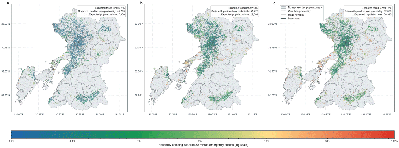
We individually evaluated each of the approximately 340,000 road segments in Kumamoto Prefecture. If a mere 3% of the prefecture’s total road network becomes impassable, 22,381 people lose 30-minute access to emergency medical care facilities.
Neither the number of hospitals nor the number of ambulances decreased. It is not the destinations or means of transport that were lost, but the means of connecting them.
Moreover, the impact is highly uneven across the road network. 83.9% of all road segments could each individually be severed without causing anyone to lose 30-minute access to an emergency medical care facility. On the other hand, the closure of the single most critical segment would cause 18,249 people to lose that access. The portions of infrastructure that actually need protection are much fewer than most assume.
The impact is also disproportionate for different age groups. Of those affected, 39.3% are elderly, defined as those aged 65 or older. Among the total population of Kumamoto Prefecture, 31.1% are elderly. In other words, any single disaster is significantly more likely to affect elderly people than other age groups.
With respect to access to firefighting services, a similar pattern is observed. Following the earthquake, the percentage of residents within 10 minutes of a firefighting unit remains high, at 83.5 to 99.8% in each ward of Kumamoto City. However, the percentage is 20.1% in Amakusa City, 4.7% in Kamiamakusa City, and a mere 1.6% in Minamata City. In each of these cities, more than 40% of residents are aged 65 or older.
[Click to enlarge]
The Story Is the Same for Water Supply, Shelters, and Toilets
In areas that lose water access, only 10% of disaster victims lived within 500 meters by road from an emergency water supply point. Increasing water supply truck deployment does not reduce the distance.
We also examined the possible effects of rainfall following the earthquake. Under the scenario of heavy rainfall hitting the already destabilized ground, 1,107 people are expected to become isolated by landslides, and 54% of them would be aged 65 or older.
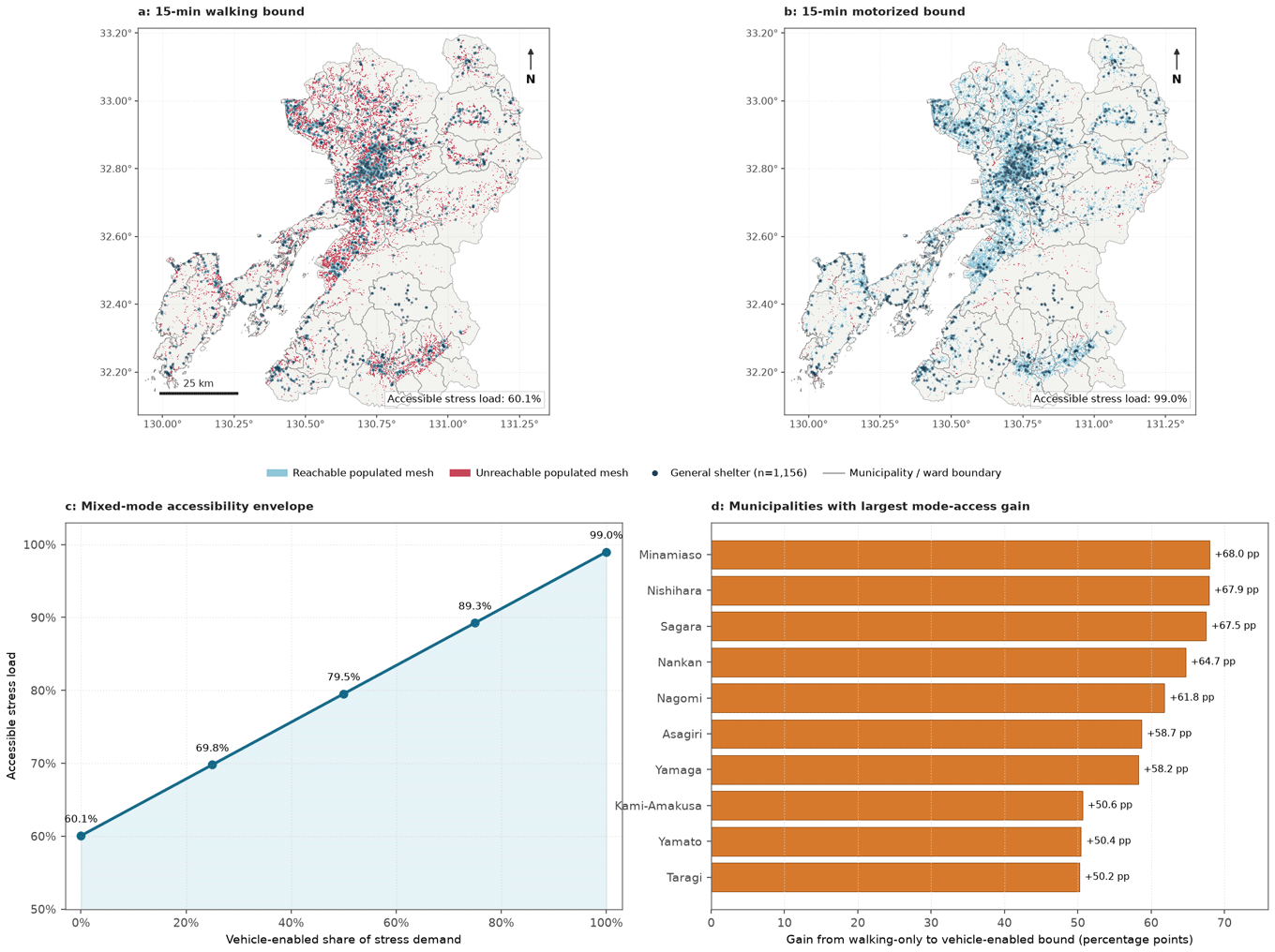
Evacuation shelter access is no exception. Assessing access to the 1,156 designated shelter facilities in the prefecture, we found that only around 60% of the total number of potential shelter users can reach the nearest shelter facility within a 15-minute walk. However, if automobile access is universally available, the figure rises to 99%.
We simulated doubling the capacity per shelter, from 50 people to 100 people. The metric improved, but only slightly, inching up 0.1 percentage points. Meanwhile, if half of the evacuees were able to travel by car, the figure rose by 20.1 percentage points. Accessibility, rather than capacity, is the critical factor with respect to the planning of shelters.
[Click to enlarge]
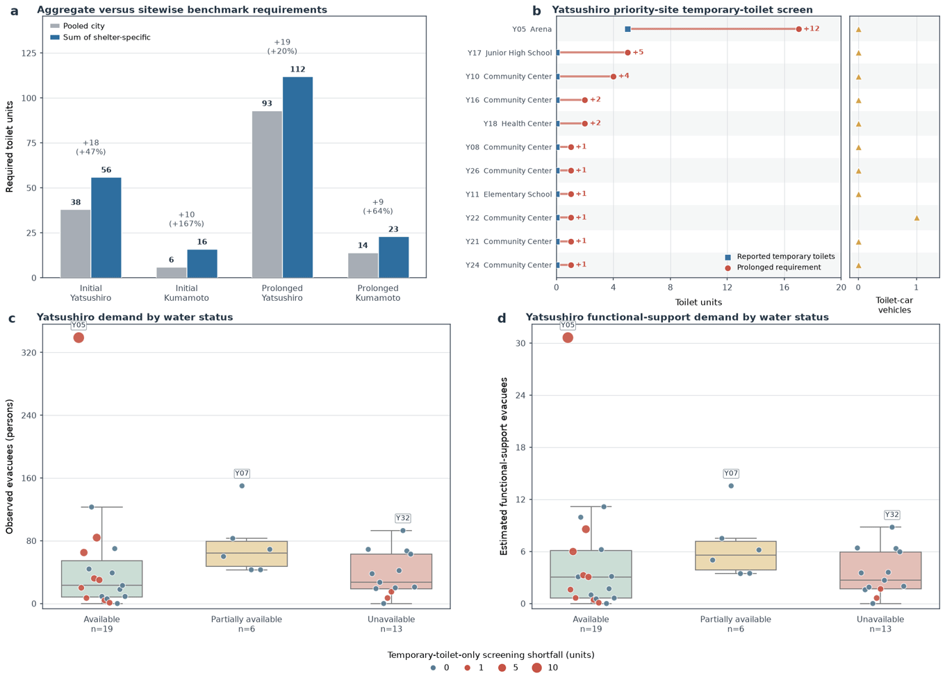
The situation is even more stark with toilet access. If the total number of evacuees across Yatsushiro City is aggregated and divided according to standard planning formulas, the city is estimated to require 93 temporary toilets. However, when the required number is calculated by summing the number necessary for each shelter, the city-wide total comes to 112. Neither the number of evacuees or calculation criteria have changed. Even so, the shelter-by-shelter approach arrives at a number that is 20% higher.
The estimated number that focused exclusively on the city-wide number of potential shelter users appeared sufficient on paper, but in reality, it is inadequate. The calculation does not match the reality of field conditions.
[Click to enlarge]
The System That Handicaps Proactive Preparation Should Be Changed
A similar disconnect with reality exists with respect to disaster management planning institutions.
When local governments implement disaster risk prevention and mitigation measures in preparation for future disasters, they have to bear around 40% of the necessary costs. However, when they undertake actual post-disaster reconstruction, national government recovery programs and tax measures reduce the financial burdens of local governments to slightly under 2%. In essence, the more advance preparation is undertaken, the costlier it is. For years, this system has been left in place unchanged, which punishes local governments that prepare for disasters.
However, the set of simulations conducted at this time has made clear that what can be done in advance has changed.
In the past, preparing for disasters meant securing additional physical resources. Now, the situation has changed. The question is: Which roads and facilities are critical to the functioning of entire communities? Those can be identified based on satellite data and public statistics, without onsite surveys. The numerical figures mentioned in this article are planning estimates, rather than the findings of field surveys. However, they are sufficient for deciding where the limited human resources and time should be deployed first.
There are not enough financial resources to secure redundancies for everything. This is precisely why it is necessary to focus on critical resources. In the case of a road network, only a tiny portion of the whole network needs to be protected. When it comes to shelters, the important thing to do is secure transportation to the facilities, rather than expanding their space. The required number of temporary toilets should be estimated on a shelter-by-shelter basis, rather than by merely using a municipality-wide metric. All of these measures can be introduced without significant increases to spending.
A larger budget is not the simple answer here. It is essential to create a system that fairly rewards proactive pre-disaster investments and to collect data that clarifies which resources are critical. The former requires institutional design, while the data are already on hand.
Disasters will continue to occur. The next one could occur at any moment. When it does, what matters will not be what resources we possess, but whether people can access them.
September 1, 2026
>> Original text in Japanese
