| Author Name | Pascal MOSSAY (University of Reading and CORE) / Pierre PICARD (University of Luxembourg and CORE) |
|---|---|
| Research Project | Theory and Empirics of Urban Growth and Spatial Structure |
| Download / Links |
This Non Technical Summary does not constitute part of the above-captioned Discussion Paper but has been prepared for the purpose of providing a bold outline of the paper, based on findings from the analysis for the paper and focusing primarily on their implications for policy. For details of the analysis, read the captioned Discussion Paper. Views expressed in this Non Technical Summary are solely those of the individual author(s), and do not necessarily represent the views of the Research Institute of Economy, Trade and Industry (RIETI).
Regional Economies Program (FY2011-FY2015)
Theory and Empirics of Urban Growth and Spatial Structure Project
In many cities, population groups are sorted into distinct spatial neighborhoods. Many U.S. metropolitan areas have a Chinatown, Little Italy, or other ethnic enclaves which host significantly higher concentrations of ethnic or cultural groups. Such enclaves may range from a single block to areas of a few square miles. For most observers, the main reason for such spatial segregation lies in the economic ties and social interactions that people have with individuals of their reference group. The prevalence of such a segregation is exacerbated by poverty as poor people are more likely to see their economic prospects and social relationships improved within their own ethnic group. Spatial concentration also affects business and professional activities. The financial, retailing, and manufacturing sectors often locate their economic activity in separate industrial areas. For instance, in Los Angeles, distinct neighborhoods host the movie, finance, fashion, and art industries. For many urban economists, such industrial concentration is partly explained by the stronger spillover that firms benefit from other firms active in the same industry.
The present research aims at improving the understanding of spatial segregation and concentration as resulting from the emergence of endogenous urban districts. We study a one-dimensional city where agents engage in intra- and inter-group social interactions, choosing their land consumption, as well as their location. Agents are heterogeneous in the sense that each of them belongs to one of two distinct populations. Intra-group interactions are more frequent than inter-group interactions: agents interact more often with agents of their own population than with agents of the other group. Such preferential interactions reflect stronger relationships between individuals sharing a common culture, language, or ethnicity. They may also reflect professional relationships between group members sharing the same economic activity (e.g., bankers, lawyers, or designers) or economic status (e.g. employed or unemployed workers). What is different from the usual literature is that our analysis does not rely on the exogenous existence of a city center. Each agent visits other agents so as to benefit from face-to-face contacts; each trip involving a cost which is proportional to distance. In equilibrium, the benefit from social interactions balances the residence and the access cost.
In this paper, we show that both populations never cluster in an integrated city. This is due to the agents' higher return from interacting with individuals of their own group. Given this, agents have an incentive to relocate close to agents of their own population, so as to meet more frequently, and therefore to save on trip costs.
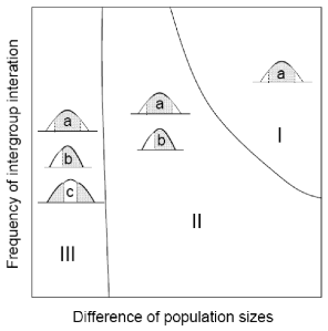
The paper also highlights different urban structures involving segregation in two or three urban districts. The main result is summarized in Figure 1. It shows the possible city structures as a function of differences in population sizes and frequency of intergroup interaction. For high differences in population sizes and frequency of intergroup interaction, only one equilibrium city structure emerges (area I). The populations self-organize in a three-district city where the larger population locates in the city center while the other one resides in the two city edges. This is represented by the pictogram (a) that displays the population density according to the spatial dimension of the city (high density in center and low density in suburbs). The white and grey zones respectively denote the smaller and larger populations.
Figure 1: City structures as a function of differences in population sizes and frequency of intergroup interaction

For lower differences in population sizes and frequency of intergroup interaction, two city structures emerge (area II). In addition to the previous urban configuration, a new configuration emerges with two districts where the populations separate in two neighboring districts (pictogram b). Finally, for low enough differences in population sizes and frequency of intergroup interaction, three city structures may emerge (area III). In addition to the two previous urban structures, a three-district city (pictogram c) emerges where the small population locates at the center. So the center may host the population with the smaller number of interactions.
This analysis shows that, for the same set of economic parameters, cities may organize in different ways. History may therefore have an impact on the prevalence of one or another urban configuration. The above urban patterns can be found for various languages, racial, or ethnic groups. For instance, the Island of Montreal, Canada presents an East-West division of the French- and the English-speaking communities. A similar North-South divide can be observed in Brussels, Belgium between the Dutch- and the French-speaking communities. While Paris, France accommodates most of the foreign ethnic groups away from the city center, U.S. cities like New York or Detroit host several small ethnic and racial groups around the city center. Spatial segregation can also have religious grounds. In Belfast, Ireland, the West and the East sides of the city are mostly inhabited by Catholics and Protestants respectively. In general, the spatial clustering of people in cities may be influenced by several other personal attributes, ranging from professional activities to sexual habits.

